Cape Verde
Cape Verde, officially the Republic of Cabo Verde, is an island nation in the Atlantic Ocean approximately 570 km west of Senegal. The archipelago consists of ten volcanic islands and several islets, with Praia on Santiago Island serving as the capital and largest city. Despite limited natural resources and a dry climate, Cape Verde has become one of Africa's most stable democracies and a notable economic success story.
History
The islands were uninhabited until they were discovered and colonised by the Portuguese in the 15th century. Their strategic location made them an important centre for the transatlantic slave trade between Africa, Europe, and the Americas. Over time, Cape Verde developed a unique Creole culture blending African and European influences. Following a long struggle for self-determination linked to the independence movement in Guinea-Bissau, Cape Verde gained independence from Portugal on 5 July 1975. Initially governed under a one-party system, the country transitioned peacefully to a multiparty democracy in 1990.
Politics
Cape Verde is a parliamentary democracy with a President serving as head of state and a Prime Minister heading the government. The country is widely regarded as one of the most politically stable and democratic nations in Africa, characterised by regular elections, peaceful transfers of power, and strong institutions. Since independence, politics has largely been dominated by two major parties: the African Party for the Independence of Cabo Verde (PAICV) and the Movement for Democracy (MpD).
Economy
Cape Verde's economy is predominantly service-based, with tourism acting as its principal growth engine. Tourism contributes roughly a quarter of national GDP and attracts over a million visitors annually, particularly to the islands of Sal and Boa Vista. Other key economic activities include transportation, trade, telecommunications, financial services, and public administration. The country has few mineral resources, limited arable land, and relies heavily on imports for food and fuel. Remittances from the large Cape Verdean diaspora also play a significant role in supporting household incomes and economic development.
Industry
Industrial activity is relatively small and focuses mainly on food processing, fish processing, beverages, salt production, construction materials, and light manufacturing. Fishing remains important, particularly tuna and other marine species, although the sector contributes less to GDP than tourism. In recent years, the government has invested in renewable energy, transport infrastructure, and digital services to diversify the economy and reduce dependence on tourism.
People and Culture
Cape Verde's population is predominantly of mixed African and European ancestry, reflecting centuries of cultural interaction. Portuguese is the official language, while Cape Verdean Creole (Kriolu) is widely spoken in everyday life. The nation is internationally renowned for its rich musical traditions, including morna, popularized by the late singer Cesária Évora. Cape Verdeans have a strong maritime heritage, and the country's diaspora, especially in Europe and North America, is larger than the resident population. This global community maintains close cultural and economic ties with the islands.
Today, Cape Verde stands out as a peaceful, democratic, and increasingly prosperous island nation whose strategic Atlantic location, vibrant culture, and growing tourism sector continue to shape its development.
Ilustration showing Cabo Verde’s location in the world off the east coast of Africa.

The Cape Verde Islands (Cabo Verde) are an archipelago of ten main volcanic islands and several smaller islets located in the central Atlantic Ocean, about 570 km (350 miles) west of Senegal on the coast of West Africa. The islands were formed by volcanic activity and feature rugged mountains, steep valleys, coastal plains, and arid landscapes.
The archipelago is divided into two geographical groups based on the prevailing northeast trade winds:
1. Barlavento (Windward) Islands in the north:
o Santo Antão
o São Vicente
o Santa Luzia (uninhabited)
o São Nicolau
o Sal
o Boa Vista
2. Sotavento (Leeward) Islands in the south:
o Maio
o Santiago
o Fogo
o Brava
The islands are arranged in a broad horseshoe-shaped pattern stretching from northwest to southeast across approximately 600 km of ocean. Santiago, the largest island, lies in the south and contains the capital city, Praia. Fogo is notable for its active volcano, Pico do Fogo, the highest point in Cape Verde at 2,829 metres. Santo Antão is the most mountainous island, while Sal and Boa Vista are flatter and characterised by sandy beaches and desert-like terrain.
Cape Verde has a generally dry tropical climate with limited rainfall, influenced by Atlantic trade winds and the nearby Sahara Desert. Despite their relatively small land area, the islands display considerable geographical diversity, ranging from fertile volcanic slopes to barren coastal plains, making the archipelago one of the most distinctive island groups in the Atlantic.
Dynamic Illustration showing the positions of the various Cabo Verde islands - use markers on the sides to scroll through the images.
![[0] Cape Verde Archipelago - V1.png](https://images.squarespace-cdn.com/content/v1/66b69c666779cb0ed6070b8b/65bcd8e6-225e-4bcc-8159-7aaded2eba92/%5B0%5D+Cape+Verde+Archipelago+-+V1.png)
![[1] Santo Antao - Cape Verde Archipelago - V1.png](https://images.squarespace-cdn.com/content/v1/66b69c666779cb0ed6070b8b/91afaf7b-abcf-4c66-8a35-e71b723c2aaa/%5B1%5D+Santo+Antao+-+Cape+Verde+Archipelago+-+V1.png)
![[2] Sao Vicente - Cape Verde Archipelago - V1.png](https://images.squarespace-cdn.com/content/v1/66b69c666779cb0ed6070b8b/a1c36289-3b48-4bc7-82c2-dac90e28edad/%5B2%5D+Sao+Vicente+-+Cape+Verde+Archipelago+-+V1.png)
![[3] Santa Luzia - Cape Verde Archipelago - V1.png](https://images.squarespace-cdn.com/content/v1/66b69c666779cb0ed6070b8b/4ee68de9-eb0e-4349-b341-4ba889f836dc/%5B3%5D+Santa+Luzia+-+Cape+Verde+Archipelago+-+V1.png)
![[4] Sao Nicolau - Cape Verde Archipelago - V1.png](https://images.squarespace-cdn.com/content/v1/66b69c666779cb0ed6070b8b/e5e68dac-c7d8-4b71-83a7-2626e1f7a78b/%5B4%5D+Sao+Nicolau+-+Cape+Verde+Archipelago+-+V1.png)
![[5] Sal - Cape Verde Archipelago - V1.png](https://images.squarespace-cdn.com/content/v1/66b69c666779cb0ed6070b8b/3baef647-0eb8-4179-b043-b23c73e019d2/%5B5%5D+Sal+-+Cape+Verde+Archipelago+-+V1.png)
![[6] Boa Vista - Cape Verde Archipelago - V1.png](https://images.squarespace-cdn.com/content/v1/66b69c666779cb0ed6070b8b/7c9b5198-b131-4094-9e5f-53619d87e1fb/%5B6%5D+Boa+Vista+-+Cape+Verde+Archipelago+-+V1.png)
![[7] Maio - Cape Verde Archipelago - V1.png](https://images.squarespace-cdn.com/content/v1/66b69c666779cb0ed6070b8b/8de555d2-4d3e-4e3d-b91c-c1679a1995d6/%5B7%5D+Maio+-+Cape+Verde+Archipelago+-+V1.png)
![[8] Santiago - Cape Verde Archipelago - V1.png](https://images.squarespace-cdn.com/content/v1/66b69c666779cb0ed6070b8b/ab947664-3483-41a5-87e2-b9caff6ab1d3/%5B8%5D+Santiago+-+Cape+Verde+Archipelago+-+V1.png)
![[9] Fogo - Cape Verde Archipelago - V1.png](https://images.squarespace-cdn.com/content/v1/66b69c666779cb0ed6070b8b/8b970a1c-ec57-43e8-9297-daf4fc6b5f94/%5B9%5D+Fogo+-+Cape+Verde+Archipelago+-+V1.png)
![[10] Brava - Cape Verde Archipelago - V1.png](https://images.squarespace-cdn.com/content/v1/66b69c666779cb0ed6070b8b/6f61a010-7a75-4922-bfbb-66788e554a41/%5B10%5D+Brava+-+Cape+Verde+Archipelago+-+V1.png)
Select an island button below for further information.
Select a button below for further information about Cape Verde.
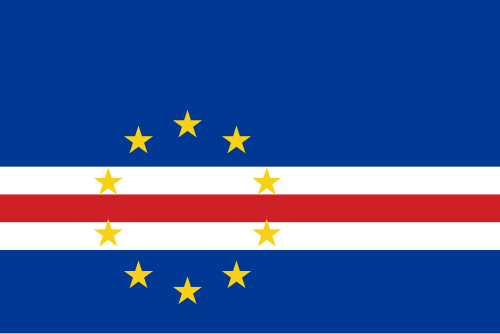
The Cape Verde Flag
The Cape Verdean flag symbolises the following: the blue represents the sky and sea; white and red represent the Cape Verdeans' desire for peace and efforts in nation-building, respectively; and the ten stars represent the archipelago's ten islands, arranged in a circle to symbolise unity